
In response to concerns raised by residents of Tollerton Park, the Parish Council has received information from the Borough Council and BGS.
Over the summer the Parish Council heard concerns from residents of Tollerton Park about the potential presence of radioactive materials in proximity to their homes.
It was flagged that Tollerton Park, Tollerton Lane may potentially be built on contaminated land. This concern raised by residents is based on a report authored by Rushcliffe Borough Council in 2008, that many residents were unaware of when they purchased their homes.
Purchasing park homes does not include land searches in the same format as the purchase of other homes and residents were therefore unaware of any potential for contamination at the time of purchase – with most living at Tollerton Park for many years and concerned about potential long term exposure to harmful substances.
Response from Rushcliffe Borough Council
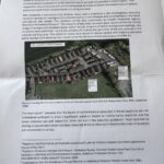
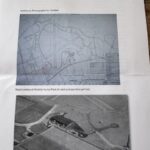
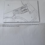
Tollerton Parish Council contacted Rushcliffe Borough Council on behalf of residents and received the following information:



Response from BGS
A suggestion was also made to enquire whether BGS held any information or surveys relevant to land in the parish of Tollerton, specifically land used as the former RAF Tollerton. The Parish Council enquiry included anything in relation to land contamination not limited to but probably arising from use as an airfield and the destruction of aircraft following from world war 2. The following information was received:
Thank you for your query concerning potential presence of radioactive materials in the vicinity of the former RAF Tollerton airfield/Nottingham City Airport (I have limited my feedback to the airfield site itself).My response is based upon the following reviewed documents/reports/programmes:
- BGS Geology mapping (1:10 000 scale) and field slips (the maps used by the geologists at the time of survey)
- Technical report WA89/9: The geology of Radcliffe on Trent
- BGS Geological Memoir for Nottingham
- DoE report: Nottingham: a geological background for planning and development
- BGS Gbase programme
- BGS/FUGRO HiRES1 programme
- BGS borehole archive
- BGS/UKHSA Radon
- EA LiDAR
Context:There have been reports in national press over many years concerning contamination arising from the maintenance/destruction of aircraft during and following the second world war. BGS has not been specifically engaged in any analysis of such sites, and following a search of archives we do not appear to hold any related information concerning this issue.A web search specifically for RAF Tollerton identifies news items that suggest the Tollerton airfield was used for aircraft disposal (but there is no further indication if this is supported by Ministry of Defence). Again, BGS holds no specific information relating to this topic, or specifically for this site.Further searches have identified that the nearby, former RAF Newton airbase was identified in 2011 (by the MoD) as a potential airbase with radioactive contamination (https://www.theguardian.com/environment/2011/dec/20/mod-radioactive-world-war-two), the search has also identified that a high resolution survey of the site was undertaken as part of plans for redevelopment of that site (I am unable to provide a direct link to the report findings as I cannot ascertain ownership of the report, and it is not BGS policy to provide links to unverified 3rd party sites, a web search for RAF Newton should provide suitable links for use at your discretion).The 1:10 000 scale geological mapping.I have reviewed the available 1:10 000 scale mapping (and associated field slips where available). These can often be a source of information concerning areas of worked/ backfilled ground. The site was surveyed in 1987- 1988 at 1:10 000 scale (https://largeimages.bgs.ac.uk/iip/mapsportal.html?id=13592323). It is a peri-urban location with a previous land use that would have possibly required some landscaping and levelling. I note that the airfield site is largely underlain by bedrock, notably the Arden Sandstone Formation (formerly Hollygate ‘skerry’), a thin but prominent sandstone bed within the Triassic-age, Mercia Mudstone Group. Superficial cover appears to be limited to “patches of thin sandy drift” except for the eastern fringe of the site., which is underlain by alluvial and lacustrine deposits (and typically offer naturally level/gentle sloping ground). Small areas of “borrow pits” into the bedrock (worked ground- typically for clay) are present in the north of the airfield and small areas of landscaped/made ground are noted on the map face near to the current main airport buildings. The words ‘minor landscaping locally on the airfield” are noted on the map face. We do not appear to hold any additional information on the nature of landscaped/made materials (they can be locally derived or bought in from anywhere). Please note that the mapping reflects what was seen the time of survey and is not a map of all previous land use. I note from the archive that the site was originally surveyed c. 1906 ( https://largeimages.bgs.ac.uk/iip/mapsportal.html?id=13588808 ) which predates the airfield, with a partial (and unpublished) revision in 1954 (for which I can find no field slips or part-works).The Technical report WA/89/9, BGS Memoir for Nottingham and DoE report: Nottingham: a geological background for planning and development.The technical report (https://resources.bgs.ac.uk/PublicationPDFs/19792743.pdf ) makes reference to the airport in the context of bedrock and superficial materials only. The digital memoir (https://webapps.bgs.ac.uk/Memoirs/docs/B06066.html) makes reference to the airfield several times, but this is also largely in the context of the underlying geology. I cannot find any specific reference to land use for the airfield. Map 4d enclosed within the DoE report: “Nottingham: a geological background for planning and development”, shows the landscaped ground delineated around the main buildings on the airfield (a boundary not shown on the 10k mapping), but there is no indication as to how the boundary was created (https://nora.nerc.ac.uk/id/eprint/510078/1/WA90001.pdf).The BGS Gbase programme.The BGS geochemical survey programme (https://www.bgs.ac.uk/geology-projects/applied-geochemistry/g-base/ ) has collected samples within/adjacent to the airport. Samples for soil were collected at one location within the airport perimeter ([461590, 336840]) and a single sample for stream sediment was collected from Thurlbeck dyke (eastern margin of the airfield [462550, 336380]). The specific analyses can be requested from BGS (Sample numbers 42_2825_+ and 42_4096_+ ). Further details of the soil sample analytes measured by the Gbase programme can be found here: https://www.ukso.org/static-maps/uk-topsoil-geochemistry.html which includes links to the UKSoil Observatory (where all the modelled values can be see in map view e.g. https://mapapps2.bgs.ac.uk/ukso/home.html?layers=NSI-GBASE-Lead,NSI-GBASE-Arsenic,NSI-GBASE-Cadmium. From the records available there does not appear to have been any radiometric analysis of the Gbase samples for elements such as Radium (this is standard practice as we have focussed on major elements and oxides only).The BGS/FUGRO HiRES1 surveyThe BGS/FUGRO HiRES1 survey was an airborne radiometric survey of the East Midlands carried out in 1998. The results of the survey are downloadable from here: https://www.bgs.ac.uk/datasets/hi-res-survey/ and can also be viewed as maps in the BGS Geoindex (e.g. https://mapapps2.bgs.ac.uk/geoindex/home.html?layers=HirResMidPOT,HirResMidTHO,HirResMidURA,HirResMidTOT,HirResMidTERN ). The resolution of the data is such that it is only suitable for regional characterisation of the geology (and therefore not suitable for site specific purposes). The interpolated data shows a range of metrics for the three main detected radiometric sources Potassium, Thorium and Uranium only. The variability of the data broadly reflects the changes in underlying geology at regional scales.The BGS borehole ArchiveI have reviewed the small number of boreholes located on the airfield site (https://mapapps2.bgs.ac.uk/geoindex/home.html?layer=BGSBoreholes&_ga=2.235564034.264709779.1753782328-202748964.1753782328). All of the records confirm the underlying geology to be ‘as mapped’. Only one record SK63NW/82 (https://api.bgs.ac.uk/sobi-scans/v1/borehole/scans/items/233222) appears to indicate ‘made up ground” to a depth of 6.78m. But no details are given about the nature of the ground, other than it coincides with a zone of lost core (which renders the description and depths uncertain). The location of the borehole within mapped superficial materials may explain the lost core and possibly the description given (the drilling was undertaken to prove aspects of bedrock)..BGS/UKHSA Radon Potential (and Radon Indicative atlas)I have included this mapping in my review although it relates to natural, geogenic radiation from Radon, rather than anthropogenic sources. The whole airport site is currently identified as a Class 1 location in the Radon potential map, which means that it is not in a Radon-affected area and that less than 1% of homes would be expected to exhibit radon gas concentrations above the recommended action level of 200 Becquerels/m3. Properties in this area (under current Guidance for England and Wales) would not require protective measures for geogenic Radon. The Radon Indicative Atlas can be viewed here: https://mapapps2.bgs.ac.uk/geoindex/home.html?layer=BGSRadon.EA LiDAR:The LiDAR for the site is provided here: https://maps.nls.uk/geo/explore/#zoom=16.0&lat=52.91999&lon=-1.07944&layers=6&b=LIDAR_DTM_1m&o=1 (courtesy of EA and the National Maps of Scotland service). There are small changes in ground level indicated in the LiDAR coverage, these are in line with localised landscaping associated with an airport site and with built structures in general. Further interpretation is beyond the scope of this enquiry response.Summary:There does not appear to be any significant evidence of extensive made ground on the airfield site (i.e. an area that might be considered a disposal point/ backfill location). Small areas of landscaping and made ground are noted. Small borrow pits to the north of the site are also noted. The underlying geology has been confirmed by boreholes (and likely comprises a notable sandstone bed). In terms of radiogenic contamination from potentially disposed materials, BGS does not appear to hold any information that would confirm this and we do not have the expertise necessary to provide an expert opinion on the likelihood of radiogenic materials being present, as this lies outside our remit (it would likely require a dedicated, high-resolution assessment of the site – given the nature of the problem) . We also do not undertake site investigation work, such as would often be the case for the redevelopment of land parcels. If you have not already done so, you could try to contact the local authority planning department to see if they are aware of any site-specific information for this area, or if they can clarify any intended ground investigations prior to changing the use of the site. Similarly, you could approach the MoD for clarification if the site has already been assessed by them, and if the legacy of the site has been documented anywhere.British Geological Survey | Nicker Hill | Keyworth | Nottingham NG12 5GG | UK